© 2020 Jerry D. Patillo
What do Flat Earthers call the southern hemisphere?! Doesn’t “hemisphere” mean “half of a sphere”? Maybe they would call the northern and southern hemispheres the “inner circle” and “outer donut”!
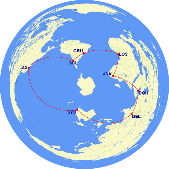
If Flat Earthers ever wanted to fly around the southern hemisphere, they may want to fly something like Fig. C.

- SYD (Sydney, Australia) to
- SCL (Santiago, Chile) to
- JNB (Johannesburg, South Africa)
- and back to SYD
On this trip, they would have to include stopovers at:
- SFO or LAX (San Francisco or Los Angeles, USA)
- DSS (Dakar, Senegal, western Africa) or LOS (Lagos, Nigeria)
- DEL (Delhi, India)
or nearby airports. I recommend going to LOS (Lagos, Nigeria) instead of DSS, because LOS is the 11th busiest airport in Africa (JNB is the busiest). DSS doesn’t even come close.[https://en.wikipedia.org/wiki/List_of_busiest_airports_in_Africa]
Now, let’s flip over this round, flat pizza called Earth, and what do we see?
If you would like to continue reading this article, please go online to https://pbcdallas.com/sub/200807-2.
If you’re already reading online, then please continue . . . .
![]() Airport Code Dictionary
Airport Code Dictionary
![]() Flight Times and Distances
Flight Times and Distances
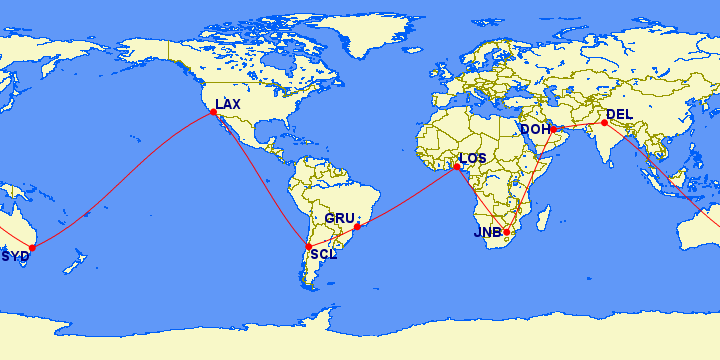
| From | To | Initial Heading |
Magnetic Heading |
Distance | ||
|---|---|---|---|---|---|---|
| 8 segment path: | ||||||
| SYD | LAX | 061° | (NE) | 048° | (NE) | 7,488 mi |
| LAX | SCL | 141° | (SE) | 129° | (SE) | 5,569 mi |
| SCL | GRU | 071° | (E) | 070° | (E) | 1,626 mi |
| GRU | LOS | 065° | (NE) | 086° | (E) | 3,945 mi |
| LOS | JNB | 144° | (SE) | 146° | (SE) | 2,803 mi |
| JNB | DOH | 026° | (NE) | 045° | (NE) | 3,863 mi |
| DOH | DEL | 076° | (E) | 073° | (E) | 1,587 mi |
| DEL | SYD | 127° | (SE) | 126° | (SE) | 6,476 mi |
| 33,357 mi | ||||||
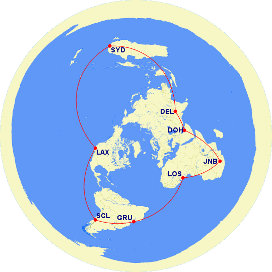
If the Flat Earthers ever wanted to travel around the southern hemisphere (“outer donut”?), they may choose something like the itinerary below:
- SYD (Sydney, Australia) to
- SCL (Santiago, Chile) to
- JNB (Johannesburg, South Africa)
- and back to SYD
Because of the limitations of today’s aircraft, they would probably include stopovers at:
- SFO or LAX (San Francisco or Los Angeles, USA)
- DSS (Dakar, Senegal, western Africa) or LOS (Lagos, Nigeria)
- DEL (Delhi, India)
or nearby airports. I recommend going to LOS (Lagos, Nigeria) instead of DSS, because LOS is the 11th busiest airport in Africa (JNB is the busiest). DSS doesn’t even come close.[https://en.wikipedia.org/wiki/List_of_busiest_airports_in_Africa]
On a “flat earth” map, the above itinerary would look something like the following.
Actually, the map above is nothing more than an azimuthal equidistant projection of the oblately spheroidal earth, centered at 90° North 122° West.