By Jerry D. Patillo © 2020
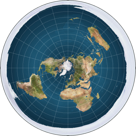
MOST — BUT NOT ALL — of the Flat Earthers DO believe the earth is round — but round and flat like a pizza. Figure 1 is “a very common map created by our Society [i.e., the Flat Earth Society] for use in online materials.” [https://theflatearthsociety.org/home/index.php/featured/maps, accessed summer of 2020]
No one has been ever able to produce a real photograph of the above “flat earths”!
Now, let’s flip over this round, flat pizza called Earth, and what do we see?
If you would like to continue reading this article, please go online to https://pbcdallas.com/sub/200807-2.
If you’re already reading online, then please continue . . . .
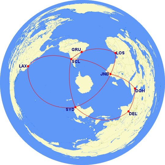
Fig. C. Circumnavigating the “flat earth’s” “southern hemisphere.” [Map adapted from xxxx.] Fig. D. Around the flat earth, with a real-world flight itinerary (August 2020) (AZEQ 90N 45W).
Fig. E. Around the flat earth (AZEQ 90S 45W).
Airport Code Dictionary
Flight Times and Distances
| FROM | TO | INITIAL HEADING |
MAGNETIC HEADING |
DISTANCE | ||
| 8 SEGMENT PATH: | ||||||
| SYD | LAX | 061° | (NE) | 048° | (NE) | 7,488 mi |
| LAX | SCL | 141° | (SE) | 129° | (SE) | 5,569 mi |
| SCL | GRU | 071° | (E) | 070° | (E) | 1,626 mi |
| GRU | LOS | 065° | (NE) | 086° | (E) | 3,945 mi |
| LOS | JNB | 144° | (SE) | 146° | (SE) | 2,803 mi |
| JNB | DOH | 026° | (NE) | 045° | (NE) | 3,863 mi |
| DOH | DEL | 076° | (E) | 073° | (E) | 1,587 mi |
| DEL | SYD | 127° | (SE) | 126° | (SE) | 6,476 mi |
| 33,357 mi | ||||||
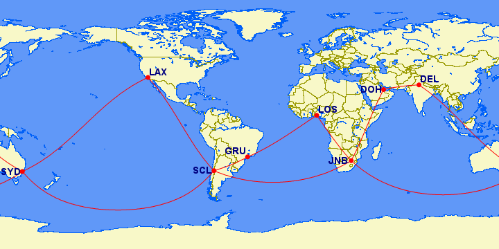
Fig. G. Around the “flat earth” itinerary (RECT 0S 45W). Fig. F. Around the real world, compared with the “flat earth” itinerary (AZEQ 90S 45W).
Distances
| FROM | TO | INITIAL HEADING |
MAGNETIC HEADING |
DISTANCE | ||
| TOTAL: | 19,657 mi | |||||
| AVERAGE: | 6,552 mi | |||||
| 3 SEGMENT PATH: | ||||||
| SYD | SCL | 145° | (SE) | 133° | (SE) | 7,060 mi |
| SCL | JNB | 117° | (SE) | 115° | (SE) | 5,734 mi |
| JNB | SYD | 135° | (SE) | 154° | (SE) | 6,863 mi |
| 19,657 mi | ||||||
Fig. H. Around the real world itinerary, compared with the “flat earth’s” itinerary (RECT 0S 45W).
Oh my God! The Antarctic ice wall has morphed (melted?) into a mass of land and ice! Click here for a collection of real photos of Antarctica from outer space. I have never seen a real photograph of the “Antarctic ice shelf” from outer space. Click here for a geological description of Antarctica.
Below is the same “flat earth” trip around the southern hemisphere on a rectangular (plate carrée, pronounced “plot kuh-RAY”) projection of the earth (fig. D.)
???? Fig. X Circumnavigate the “southern hemisphere” (Click or tap to enlarge the image. To return to this page, click on the Return or Back button [<-], NOT the Exit button [X].)
]
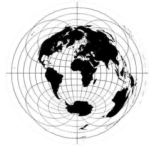
Fig. 2. Michael Wilmore’s “flat earth” map. Antarctica has morphed (melted?) into a shape we’re more familiar with and Australia’s shape has been grossly distorted. I wonder what our Aussie friends would think of this “flat earth”! [https://theflatearthsociety.org/home/index.php/featured/maps]If Flat Earthers ever wanted to fly around the “southern hemisphere”, they may want to fly something like fig. C.
MOST — BUT NOT ALL — of the Flat Earthers DO believe the earth is round — but round and flat like a pizza (fig. 1).
But even the Flat Earthers can’t agree on what the “flat earth” is supposed to look like. Fig. 2 is the “flat earth” suggested by Michael Wilmore, the Flat Earth Society’s vice-president!
[https://theflatearthsociety.org/home/index.php/featured/maps]
![]() Distances
Distances
| From | To | Initial Heading |
Magnetic Heading |
Distance | ||
|---|---|---|---|---|---|---|
| Total: | 19,657 mi | |||||
| Average: | 6,552 mi | |||||
| 3 segment path: | ||||||
| SYD | SCL | 145° | (SE) | 133° | (SE) | 7,060 mi |
| SCL | JNB | 117° | (SE) | 115° | (SE) | 5,734 mi |
| JNB | SYD | 135° | (SE) | 154° | (SE) | 6,863 mi |
| 19,657 mi | ||||||
Oh my God! The Antarctic ice wall has morphed (melted?) into a mass of land and ice! Click here for a collection of real photos of Antarctica from outer space. I have never seen a real photograph of the “Antarctic ice shelf” from outer space. Click here for a geological description of Antarctica.
Below is the same “flat earth” trip around the southern hemisphere on a rectangular (plate carrée, pronounced “plot kuh-RAY”) projection of the earth (fig. D.)
???? Fig. X Circumnavigate the “southern hemisphere” (Click or tap to enlarge the image. To return to this page, click on the Return or Back button [<-], NOT the Exit button [X].)